

Vanport flood 1948, photograph courtesy of the Oregon Historical Society archives.
CEOAS co-director looks at the Vanport disaster through a new lens
Research on systemic racism, a flood in 1948 and online education. What do the three of these have in common? The work of CEOAS Water Conflict Management and Transformation program co-director, Lynette de Silva, of course.
De Silva is one of many expert Oregon State University instructors who are taking a look at history through a new lens, asking important questions about things like how race played a part in historic disasters. As climate change continues to disproportionately harm historically marginalized communities, de Silva’s examination of past mistakes in urban watershed management can help planners, analysts and scientists create a more equitable and climate-resilient future.
Those familiar with Oregon history are likely to cringe when they hear the word “Vanport.” The story of this expansive Multnomah County housing development and the epic flood that washed it away in 1948 is central to understanding the Black experience in Oregon.
De Silva is taking a new look at this historic event through the lens of transformative conflict analysis. This approach emphasizes addressing the underlying conditions giving rise to a conflict, and it offers tools to change those conditions through stakeholder engagement. De Silva is specifically interested in using this approach to address water-related conflicts, which can be especially challenging.
The Vanport story
A perfect storm of racism, poor urban planning and flood management, bad weather and community history converged in the Vanport disaster.
As World War II ramped up, Portland shipyards began pumping out ships as fast as they could. Laborers flocked to Portland for the abundant shipyard jobs. Workforce housing was desperately needed, especially for Black workers, who were excluded from living in most Portland neighborhoods by racist policies and laws. Vanport was built to fill that need. It was a massive development of nearly 10,000 inexpensive units constructed very quickly in a diked floodplain of the Columbia River. Vanport grew to be the largest Black community in the state, home to institutions like the Vanport Extension Center, which later became Portland State University.
After the war, some residents started to move out of Vanport, but other housing options were still limited for Black people and other people of color (such as Japanese Americans who had been released from internment camps), so many stayed. By 1948, the Vanport population included 18,500 residents.
Then came the flood. In late May of 1948, snowmelt and heavy rainfall caused the Columbia to rise and overflow its banks. Despite being in a floodplain, Vanport was not evacuated, and residents were specifically told they were safe. When Vanport did flood, the tragic result was the loss of 15 lives and the total destruction of the development. The flood not only destroyed physical homes and everything in them, but also scattered a vibrant community.

Lynette de Silva’s main research focus includes water conflict management, integrated watershed management, and the study of transboundary waters.
A new way of seeing Vanport
To de Silva, Vanport was a water-related story but it was really much more than that. “I was really using Vanport, a story that I knew, to challenge the transformative water conflict analysis framework. I wanted to ask, ‘What does this framework have to offer? Does it work?’”
She applied two techniques to examine the Vanport story: construction of a situation map and placement of the story into one of the four stages of water conflict transformation.
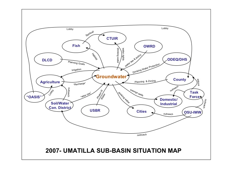
A situation map is a tool for visualizing the interconnected nodes and systems that relate to a given topic. These maps resemble flow charts – boxes containing entities or concepts are connected by lines that describe the relationship between the boxes. Check out an example of one of these maps.
“Situation maps can characterize the complexity of a system, recognizing that their components are interconnected in lots of ways,” de Silva explains. “I wasn’t sure I was going to learn anything new using this tool, but it did crystallize a few things for me.”
One of those things was the importance of agency on the part of Vanport residents. Community members were far from passive about the racial bias they faced; in fact, the Black Vanport community founded the Vanport Interracial Council to advocate for themselves and address broad community concerns. The situation map revealed just how active and important the Vanport Interracial Council was.
De Silva next tried to determine where the Vanport story fit within the four stages of the water conflict transformation framework. Each stage — adversarial, reflective, integrative and action — calls on different collaborative skills to help mitigate conflict. Vanport fell squarely in the adversarial stage, de Silva decided.
“This is the realm of laws and policies, tactical control of information, and a ‘defend and debate’ communication style,” de Silva explains.
To proceed and work through the adversarial stage, trust-building and listening are the main skills needed, according to the framework.
“But trust-building and listening sounded kind of trivial to me,” de Silva says. “What I learned as I dug deeper is that in order to build trust one has to demonstrate trustworthiness, and there has be fairness and non-discrimination,” certainly missing in the Vanport story.
Could it have been avoided?
One of the hardest questions to answer is whether the Vanport tragedy could have been avoided. De Silva herself isn’t quite sure. “This analysis made me think that perhaps the [African American] Vanport community did everything they could at that time – they had agency, as revealed in the situation map, but mutual trust and listening within the broader community was lacking,” de Silva says. “So the question then was, for that time frame and in that dynamic, what else could have been done?”
“I don’t have all answers but I do know that in conflicts such as these, often the science ends up being the easy part,” de Silva continues. “The social and economic factors are far more complex.”
For more …
To learn more about Vanport, check out resources provided by the Oregon Historical Society and Vanport Mosaic.
If you’re interested in taking a water conflict management course or pursuing a graduate certificate online, get more information about your options today.


